March 2-3, 2015
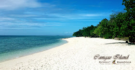
White sand, turquoise seas, uninhabited island, pristine, and clean. These are the qualities of a beach getaway you have always wanted. Add the word cheap, and there's nothing more you can ask for. Located at about five kilometers off the shores of Matalom, Leyte's town center, there is no doubt this is one of the best beach getaway of Eastern Visayas.
Canigao Island is an elliptical islet no more than 480 meters across its longest side. All of its sides are powdery white sand and its center is filled with coconut trees. It is situated along Matalom sea and is midway between mainland island province of Leyte and the northern coral reefs of Bohol.
Its western side is facing the wide sea between the island of Leyte and Cebu giving a perfect scene for the sunset while its eastern side is facing the mountains of Southern Leyte.
The municipality of Matalom was able to maintain its cleanliness in fact waters remain turquoise and clear making this island also a great place for snorkeling.
Facilities has been built along the island with cottages available as well as a shower room and a rest room within the island's center. The local government of Matalom is also assigning two police officers in weekly rotating shifts to guard the island.
True to its name as cheap, the boat fee to get to the island is only Php 55 however they require that at least the boat gets to be at least nearly at full capacity of 25 before leaving. So the best and cheapest way to get to the island will be to be in a group. As for us, we are only two when we got there but they have allowed up to pay half of the boat's capacity so we can get to the island.
Things to do in Canigao.
Scenery is awesome, beach bumming is as usual, inevitable.
Snorkeling, although the underwater species is not as rich as other virgin beaches; starfishes, striped rockfishes, and anchovies proliferate the area.
A faint yellow-light lighthouse is within the island center although its light is not disturbing if darkness is what you wish for a starlit night in the island as the coconut trees are blocking off the light.
Diesel generator is available to power up the island at night time for basic lighting use.
How to get to Canigao
A trip to Matalom, Leyte and a 5-kilometer boat ride to Canigao (coordinates 10.24862N 124.74966E) which would take about 20 minutes.
Coming from Manila, you may ride a plane to Tacloban. From Tacloban New Transport Terminal (coordinates 11.23923N 124.98779E), it is a 3-hour ride via vans called Duptours or Van-vans heading to Maasin, Southern Leyte for Php220. Drop-off at Matalom town center.
Previously, the jump-off is between kilometer marker 1113 and 1114 however after Typhoon Haiyan (loc. Yolanda), the transport to Canigao has been centralized and controlled by the local government. Now it is located at the town center by the back of the public market between kilometer marker 1109 and 1110 (coordinates 10.28126N 124.78409E)
It is best to go there as group and as much as possible be in a group of 25 so the boat ride will be as cheap as Php 55 per pax.
You may contact Ms. Belen for reservations or inquiries at +63 (926) 8176886. She is kind to personally arrange a discount for us learning that we are only a couple and no one is around to share costs with us on the boat. Just mention her my name or my blog so she can remember.
 |
| Ate Belen of Canigao souvenirs |
Costs for staying in the island
You can rent a tent for Php 250 or bring your own tent and only pay Php 100.
Cottages are available for Php700 or a house for Php1500
The trip to Canigao Island is part of our 7-day mapping expedition to the eastern seaboard of the Philippines; covering 13 provinces from Mindanao's Caraga Region to Eastern Visayas and Bicol which acquired over 500 waypoint data and covered over 2,700 kilometers of roads, trails and ferry routes. The data has been donated to OpenStreetMap Philippines and a GPS routable map of the Philippines is being compiled by Schadow1 Expeditions regularly to which it can be used for navigation assistance for tourism and humanitarian purposes.
Map
Google Maps (link)
Schadow1 Expeditions Contributions (link)
How to use for your Navigation System (link)
2015 East Philippine Seaboard Mapping Expedition Articles
- East Philippines Seaboard Mapping Expedition 2015 Part 1
- East Philippines Seaboard Mapping Expedition 2015 Part 2
- East Philippines Seaboard Mapping Expedition 2015 Part 3
- East Philippines Seaboard Mapping Expedition 2015 Part 4
- Portuguese Man-o-War on Island Hopping to Siargao
- Tinuy-An Falls - Multi-tiered and Widest Waterfall in the Philippines
- What is with this small paradise called Canigao Island
- The Magnificence of Hinatuan Enchanted River
- Island Hopping Guide at Siargao Islands
- Magpupungko Beach and Natural Pool of Siargao Islands
- The Surfing Capital of the Philippines - Cloud 9 Siargao


No comments:
Post a Comment