 |
| Nielson Field, January 1945 |
Have you ever wondered that 68 years ago, Nielson Airfield is the first commercial airport in Asia? Built last 1937 and has been immensely destroyed during the Battle of Manila on World War II last March 1945. Unknown to most of us, a once military and commercial airfield is now a bustling ultra urbanized city in the Philippines.
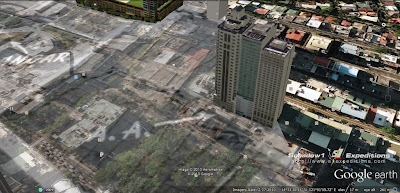
What remains of this airfield is a solitary building which was once an air operations office in a middle of a park amidst high-rise buildings. This location is now far from being an airport.
The once runway is now a busy Ayala Avenue and Paseo De Roxas of the Makati Central Business district. Once, propeller planes rule the concrete pavement; yet now is ruled over by cars and buses plying daily to transport to and from this busy city the workforce of Makati.
 |
| The present day Makati |
 |
| The Nielson Airfield overlay on the present day Makati |
What remains of Nielson Field that reminds us of the past are the once runways which are now Ayala and Paseo De Roxas to which, Ninoy Aquino's monument is place at the middle of its intersection. Additionally, Legazpi street has been preserved which is shown by the street visible at the right of the photo. The operations office has also been preserved which is located at the triangular space between the runways. The area is now the Ayala Triangle park and the building is now the Nielson Tower which houses the Filipinas Heritage Library.
 |
| The once operations office, is now a library at the middle of Ayala Triangle |
 |
| The Hangar and Boneyard (junk aircraft parts) is now the Greenbelt Commercial Center |
 |
| The Camouflage netting is now Urdaneta Village |
 |
| The unfinished runway which was heldback by the war is now where the Enterprise Building is. |
 |
| The once it calls as A.A. is now the present Biltmore, Somerset Millenium Hotel and the Greenbelt Radisson's Condominium |
The airport used by Far East Asia Air Force of the United States during their colonial rule in the Philippines is no other than Makati CBD of today.
 |
| Makati CBD and the Ayala Triangle (lower right) which was once an airfield 68 years ago. |
Map
Google Maps (link)
Schadow1 Expeditions Contributions (link)
How to use for your Navigation System (link)

No comments:
Post a Comment