According to the United Nation's World Risk Index of 2011, the Philippines is ranked third of 173 nations that is most vulnerable to disasters. Yearly, the country is visited by super typhoons and monsoon carrying torrential rains; as such, flooding has been a rampant issue to which it frequently results to damage to agriculture, property and human lives. The force of nature is inevitable yet preparedness is crucial before a calamity occurs while immediate response is needed as the calamity passes. Precise actions for preparedness and rescue is the real deal when a calamity strikes; and such precision can only be attained through availability of tools that helps the local government decide to reduce the risk every time a geomorphologic event happens in a locality. And these tools are highly dependent on maps with accurate and recently updated data. Schadow1 Expeditions has heed the call and joined the project headed by Environmental Science for Social Change in collaboration with Openstreetmap Philippines in training the local government units of Lubao, Pampanga on mapping their locality.
Sunday, October 27, 2013
Wednesday, October 16, 2013
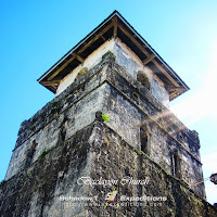
Baclayon Church - a glimpse of a rich architectural past of the Philippines
Constructed in 1724, the Baclayon Church of Bohol stands as the oldest church in the Philippines and was built as the first parish church of Jesuit missionaries in the Philippines. The structure is not only the religious capital of Baclayon for the Catholics but as a world heritage site for Boholanos and the Filipinos. The church is listed as one by the United Nations as a cultural importance for the Philippines. We have been to this church as part of our mapping expedition in Bohol last 2010.
Labels:
Architecture,
Bohol,
Heritage
Location:
Baclayon, Philippines
Monday, October 14, 2013
Nielson Airfield - what is now an ultra urbanized business district
 |
| Nielson Field, January 1945 |
Have you ever wondered that 68 years ago, Nielson Airfield is the first commercial airport in Asia? Built last 1937 and has been immensely destroyed during the Battle of Manila on World War II last March 1945. Unknown to most of us, a once military and commercial airfield is now a bustling ultra urbanized city in the Philippines.
What remains of this airfield is a solitary building which was once an air operations office in a middle of a park amidst high-rise buildings. This location is now far from being an airport.
Saturday, October 12, 2013
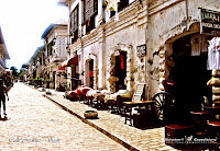
A Time Machine in the Philippines - Vigan's Calle Crisologo
If there is a remaining village in the large island of Luzon that takes you more than a hundred years back in time, there would only be one and that is Calle Crisologo. This 417-meter cobblestone street at the heart of Ilocos Sur's Vigan would take you back to the past as if you just rode a time machine.
Wednesday, October 9, 2013
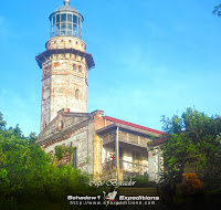
Cape Bojeador Lighthouse and the stunning West Philippine Sea
Atop a 70-meter hill while driving along Maharlika Highway for 14 hours coming from Cavite, is a magnificent lighthouse designed by Magin Pers way back 1887. It is one of the three lighthouses in the island of Luzon which he designed to guide the seafarers way back the Spanish colonization era of the Philippines. It is a must-visit as you travel along the northernmost tourist locations of Luzon.
Wednesday, October 2, 2013
Skyranch - Touch the sky and get thrilled with the view of the smallest volcano.
Skyranch is the newest leisure park in Tagaytay City. Known for the biggest and highest ferris wheel in the Philippines located 605 meters above sea level. Riding this wheel is surely a must-try for those who dig for heights.
The park is beside Taal Vista Hotel and is along the Tagaytay-Nasugbu Highway (Aguinaldo Highway)
The park is beside Taal Vista Hotel and is along the Tagaytay-Nasugbu Highway (Aguinaldo Highway)
Subscribe to:
Comments (Atom)


